Photogrammetry in Heritage Documentation
Published 29 April 2026
Photogrammetry — the science of deriving measurements from photographs — is not new. Surveyors used it for topographic mapping in the 19th century, and architectural historians have employed close-range photogrammetry for building documentation since the 1960s. What has changed fundamentally over the past decade is accessibility: the combination of affordable digital cameras, consumer drones, and free or low-cost Structure-from-Motion (SfM) software has put precise 3D documentation within reach of heritage practitioners who could not previously afford specialist equipment.
How Structure-from-Motion Works
SfM algorithms identify matching features — distinctive corners, edges, and textures — across large numbers of overlapping photographs taken from different positions. By tracking how these features shift across the image set, the algorithm computes the position and orientation of each camera at the moment of capture, and simultaneously reconstructs the three-dimensional geometry of the photographed scene.
The output is a dense point cloud — millions of georeferenced points, each carrying colour information extracted from the photographs. This point cloud can be meshed into a continuous surface, textured with photorealistic detail, and used as the basis for measured drawings, volume calculations, interpretive visualisations, and monitoring comparisons.
Software packages including Agisoft Metashape, RealityCapture, and the open-source OpenDroneMap have made this pipeline accessible to practitioners without backgrounds in geodesy or computer science. The main investment is time: a thorough photographic coverage and careful processing.
Rock Art Documentation in Australia
Australia holds one of the world’s richest concentrations of rock art, with sites ranging from Murujuga (the Burrup Peninsula) in Western Australia — which contains some of the world’s densest concentrations of petroglyphs — to the Quinkan rock art sites in Queensland and Gwion Gwion paintings in the Kimberley.
Photogrammetric documentation has become a standard tool for recording rock art sites that are at risk from weathering, vandalism, or development pressure. By creating photorealistic 3D models of rock surfaces, practitioners produce records that capture not only the imagery but also the texture and topography of the surface — information that enables researchers to detect and track physical deterioration over time.
The Murujuga Rock Art Monitoring Programme, a collaboration between Murujuga Aboriginal Corporation, industry partners, and researchers from the University of Western Australia and Griffith University, has used photogrammetry alongside other monitoring methods to establish baseline records and detect change across a selection of high-priority panels.
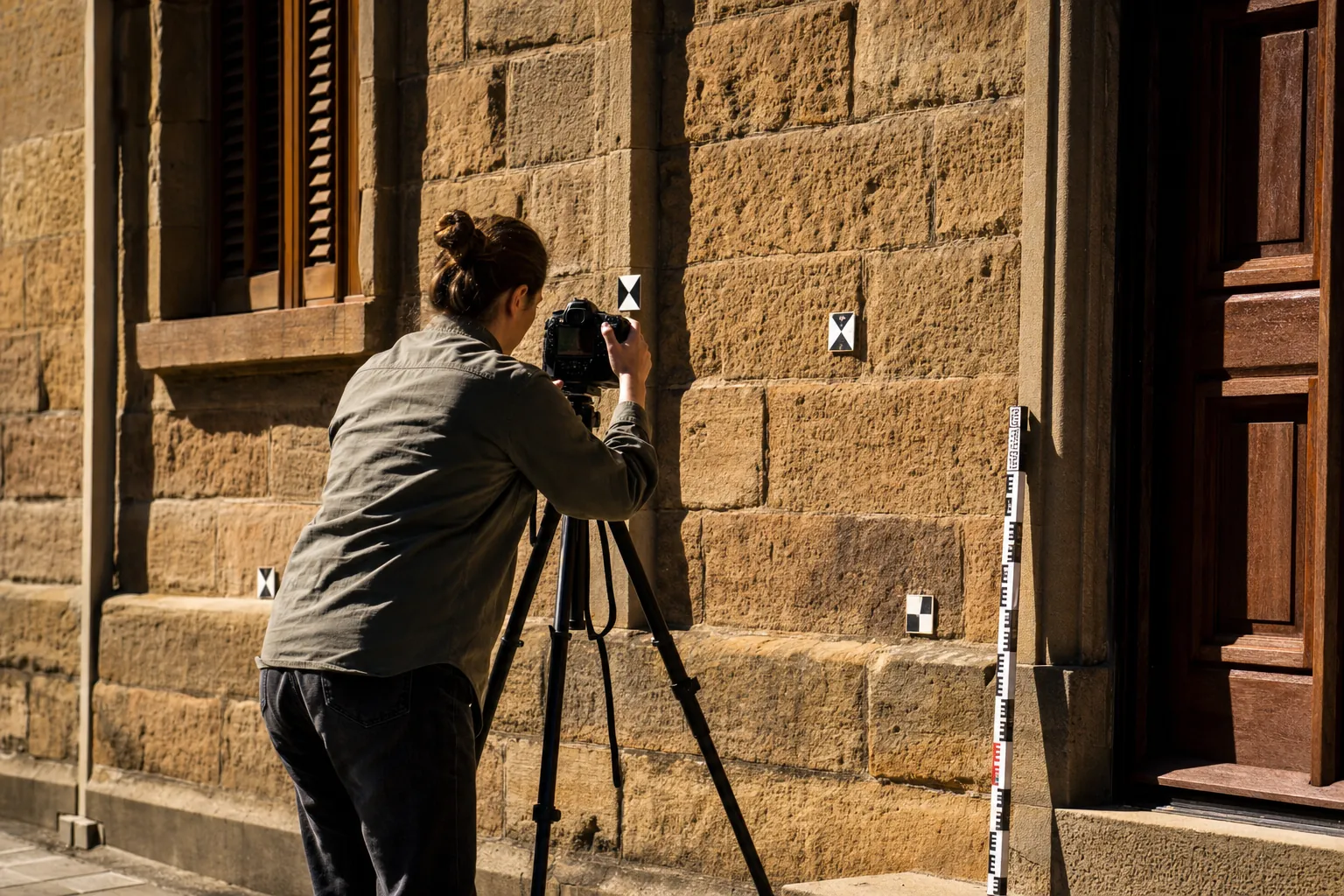
Historic Building Documentation
For built heritage, photogrammetric documentation provides an efficient means of producing precise geometric records of buildings and structures that conventional measured drawing would require significantly more time and resource to achieve.
Heritage-listed buildings in Australia are increasingly being documented with SfM at the time of consent for significant works, providing a baseline record that can be referenced if fabric is damaged or lost during construction. This documentation feeds directly into broader collection digitisation workflows used by state heritage agencies. In cases of heritage buildings damaged by fire, flood, or structural failure, photogrammetric records have enabled informed restoration work to proceed with confidence about original dimensions and details.
The Queensland Heritage Council and Heritage Victoria both include photogrammetric documentation within their guidance for heritage impact assessments of significant buildings. The level of documentation required is calibrated to the significance of the place and the nature of the proposed works.
Drone-Based Aerial Photogrammetry
Consumer drones equipped with high-resolution cameras have expanded photogrammetric documentation to scales that ground-based photography could not efficiently achieve. A drone can photograph a large earthwork, a complex of archaeological features, or an entire historic precinct in a fraction of the time required to cover the same area on foot.
For archaeological survey, drone-based photogrammetry has largely replaced traditional plane-table survey and significantly supplements ground-penetrating radar and magnetometry surveys. By producing orthophoto mosaics and digital elevation models of survey areas, practitioners can map surface features, monitor erosion and site disturbance, and integrate spatial data from multiple survey methods within a single GIS environment.
CASA (Civil Aviation Safety Authority) regulations governing drone operations in Australia require operators to hold a remote pilot licence for commercial operations and impose specific requirements around operating height, proximity to people and buildings, and airspace classification. Heritage practitioners working in remote areas typically find these requirements straightforward to meet; those working in urban or built-up areas must navigate more complex airspace management requirements.
Limitations and Complementary Methods
Photogrammetry performs best on textured, matte, static surfaces in good light. Highly reflective surfaces, dark materials with little texture, and environments with rapidly changing light all degrade model quality. Interiors, where controlled lighting is more important, often require dedicated lighting rigs and more careful image acquisition planning than outdoor contexts.
For heritage applications requiring the highest geometric precision — conservation measurement, fit-checking for prosthetic repairs, monitoring of small-scale dimensional change — photogrammetry may need to be complemented by contact measurement or structured light scanning. The two technologies are complementary rather than competing: photogrammetry excels at large-scale textured surfaces, while structured light scanning provides superior precision for small, complex geometries.
The integration of photogrammetric data with laser scanning data — producing hybrid point clouds that combine the coverage efficiency of SfM with the geometric precision of lidar — is increasingly common in major heritage documentation projects, and processing software has advanced to handle mixed-source datasets with growing effectiveness.